
Written by David Johnson
Thanks to cutting-edge tech, the goal to get as many people as possible on SELT trails is no longer impossible.
It all started with a polite phone call. One day, at the height of the pandemic, the phone rang. Deborah Goard, SELT’s Stewardship and Land Engagement Director answered. On the other end of the line was Amanda Kelly, an Exeter resident and mother to young daughter with a disability. As everyone was during those days of social distancing and quarantining, Amanda eagerly yearned to get outside, breathe fresh air, and enjoy a view other than a computer screen.
She and her daughter – who uses a wheelchair – made their way to Mast Road Natural Area, one of SELT’s properties with wider trails, more accessible than others for wheelchairs. Unfortunately, the gate wasn’t quite wide enough for her daughter’s particular wheelchair, so Amanda gave Deborah a call and two talked at length about the needs for accessibility on local trail systems.
And that’s how Mission: Access began.
It was August 2022 when seven individuals gathered to kick off a new era in trails accessibility for SELT. With a laptop open on the conference room table, they peered at numbers and grids and all manner of digital potpourri, while soaking in what they were learning from Todd Ackerman of Beneficial Designs, a rehabilitation/accessibility research and design firm located in Nevada.
Meanwhile, waiting in the hallway just outside around the corner, ready for action, was the object of all that learning: the HETAP device. HETAP stands for High-Efficiency Trail Assessment Process. At first glance the apparatus may not look like something futuristic – think three-wheel jogger stroller crossed with a PlayStation 5. Make no mistake: this is a cutting-edge piece of design that will unlock SELT’s trails for more users.
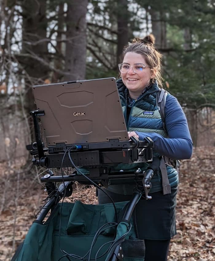 The HETAP captures and inventories objective information about trail conditions, including grade, width, and obstacles and barriers. The data can then be used by SELT’s stewardship crew to enhance trail safety and efficiently maintain properties. Even niftier: accurate, detailed information about trail conditions will then be made available to the public, allowing users to gather as full a picture as possible about the specific trails and how they measure up to their respective capabilities.
When it comes to long-term stewardship goals, the process allows SELT’s stewardship staff to address environmental impacts on trails, identify and mitigate potential barriers like roots, rocks, and difficult terrain, and update existing management plans. While all of that sounds like it would require, give or take, 12 million hours worth of work, well, that’s the beauty of HETAP – particularly those first two letters of the acronym: “High-Efficiency.”
The process is set up to be done by one person, and with the technology shouldering the data-crunching load, a single user can conceivably map out two to three miles of trails in one day.
“As the number of trail systems that we are responsible for has grown, so too has our land management responsibilities,” says Deborah. “Not only will the HETAP provide a highly efficient way to inventory and better understand these trails for our stewardship purposes, it also opens the door for a more diverse population to access and enjoy these properties.”
Deep diving into the tech involved in bringing this vision to life can easily produce an ice-cream headache, but here’s the layperson rundown of how it all works:
To start, the user calibrates the device on a smooth, flat surface, establishing a baseline reading. Then it’s onto the trails, where the user navigates with the specialized pushcart, which is outfitted with measurement sensors that collect data like GPS coordinates, grade, slope, width, obstacles, features, and terrain.
The captured data is then available to be downloaded as a spreadsheet, which SELT’s stewardship team can adapt into consistent information about a trail’s difficulty level, allowing users to select recreational options that fit their abilities. Click here to view our currently mapped properties.
That’s where the efficiency comes into play. Gone are the analog days of hand-held tools and chicken-scratching on notebooks. The HETAP represents a more streamlined approach to data collection and the result is more trails, done in less time.
"Not only will the HETAP provide a highly efficient way to inventory and better understand these trails for our stewardship purposes, it also opens the door for a more diverse population to access and enjoy these properties."
“The length of time to capture data on the trail will depend on how feature-heavy it is,” says Todd Ackerman. “By features we mean multiple rocks, roots, trees, really anything that causes an issue for a hiker, that would make the trail a little more challenging.”
So what’s the upshot to all this technology and training? Information.
“In the near-term, we will be able to provide comprehensive details about our trails, equipping users with the knowledge of what awaits, and allowing them to make their own informed decisions about what trails to try out,” says Deborah. “In the future, this data will help inform us in regards to which sections of trails we can focus on to make more accessible for people who have mobility challenges.”
For Amanda, these efforts mean a great deal, both for her daughter and others who are craving similar outdoor experiences.
“Everyone should be able to enjoy the benefits of these trails,” she says. “Nature is amazing and something we all need to be exposed to and embedded in. City sidewalks are one experience – and it’s a good one – but we need to be in the forest and on a mountain and experience those spaces.”