

Written by David Johnson
Photos by Jerry Monkman and David Johnson
What does a conserved woodland have to do with what comes out of your kitchen faucet? Just about everything.
Let’s close our eyes and conjure up a memory of elementary school: the gymnasium, a crush of people milling about, a buzz of excitement that mixes with the faint scents of vinegar and Magic Marker. That’s right – it’s Science Fair day. As far as the eye can see: tempera-painted Styrofoam balls in orbit, papier-mache volcanoes belching out foul liquids, a handful of dirt cups, and, of course, that one kid with the working nuclear fission reactor made out of old VCR parts.
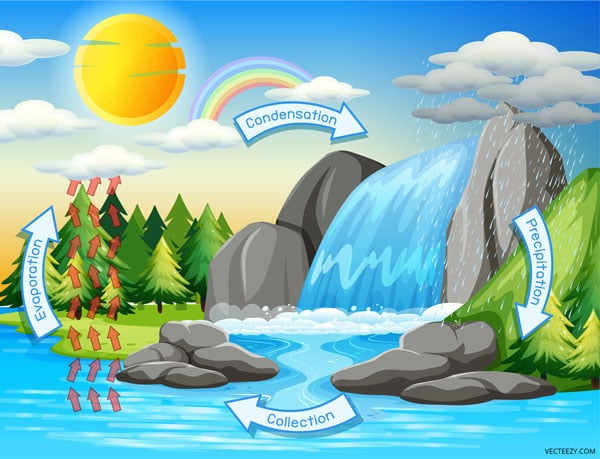
Amidst this menagerie, you can find the trusty Science Fair standby: the water cycle. Colorful posters! Cotton ball clouds! Fresh grass clippings from Aunt Hazel’s front yard! Regardless of the presentation, the takeaway was always the same: few environmental processes in the natural world are as consequential as the water cycle.
And for good reason: because as we open our eyes and return to the present, we are reminded of how watersheds and evaporation and rainfall and filtration are as important as ever – and that conserving the lands that keep our drinking water drinkable is of the highest priority for SELT.
Which brings us to Auburn, NH.
THE SANBORN PIECE OF THE PUZZLE
Lake Massabesic’s 2,500 acres sit within the borders of Auburn and Manchester, providing drinking water to Manchester, Hooksett, Auburn, Bedford, Goffstown, Derry, and Plaistow. Buttressing the lake are over 8,000 acres of watershed protection, as well as 70 miles of fire roads and hiking and biking trails. To say that Massabesic is one of the most important bodies of water in New Hampshire is not hyperbole; it is a literal life-source for over 160,000 people.
Conserving the Massabesic watershed, then, becomes an enormous priority, and is why when the chance to secure a conservation easement on the Sanborn property in Auburn surfaced, SELT and the Auburn Conservation Commission – who had long considered the Sanborn property a key conservation priority – leapt at the opportunity.
These 220-acres that had been with the Sanborn family for six generations provide an important piece to the watershed jigsaw puzzle, highlighted by Murray Mill Brook, a Massabesic tributary that flows through the heart of the property.
“Protecting a watershed in its natural condition generates a ripple effect in nature,” said Jeremy Lougee, Conservation Project Manager and Farmland Coordinator for SELT. “The Sanborn easement will provide long-term benefits to wildlife, outdoor recreation, agriculture, forestry, scenic views, carbon sequestration – the list goes on!”
“We are thrilled,” said John O’Neil, Watershed Land and Property Manager for Manchester Water Works. “It is a great sized easement for southern New Hampshire and to have it along one of our main tributaries is fantastic.”
Robert Sanborn knew he could have pursued more lucrative paths for his highly desirable land (Auburn is, after all, one of the most rapidly developing towns in New Hampshire). But he felt the true value of his land was bound to a different future, one of drinking water protection, wildlife habitat, and outdoor recreation.
“There are very few things in life you can leave that are permanent.”
And it goes beyond a simple conservation legacy as well. There is deep-rooted family history woven into the property, a history that Robert and his wife Brenda, were unwilling to see swallowed up in a sea of cul-de-sacs.
“There are very few things in life you can leave that are permanent,” he said.
From the time it served as his grandfather’s dairy farm and Robert spent his formative years exploring the wilderness on the weekends, one memory stands out: as a young child, Robert got hopelessly lost in the sprawling woods and as a last hope he turned to Betty, the Collie with him and said “Let’s go home” and Betty promptly led him right back to the farmhouse.
GOING WITH THE FLOW
The concept of a watershed is straightforward: when precipitation falls, the rainwater flows across the landscape before pouring into streams and rivers. As the rainwater snakes across the ground, it will pick up sediments and materials in its path. This “H2O Express” will not discern among its passengers, so it is critical that what ends up getting deposited is as non-toxic as possible.
As development of these surfaces within watersheds increases, water quality is affected. Essentially: the more these areas are developed, the greater the chance water quality will be degraded (research has shown that development of over 5% of impervious surfaces can result in negatively impacted water quality).
 Increased development on a watershed opens up the possibility of rainwater picking up chemicals, fertilizers, oils, pesticides, and various other sundry hop-ons. Watershed conservation easements ensure that nature’s organic buffers stay intact, filtering rainfall and remaining clear of ground-level pollutants.
Put another way: watersheds are the first line of defense between impurities and your kitchen faucet.
“These conservation easements are a great tool for our partners like SELT to take the lead on,” said John O’Neil. “They help us to expand the buffers on the tributaries that help keep the ponds and lakes free of sediment loading. These lands help filter runoff and keep water contaminant-free.”
“Lake Massabesic is a vital asset to the Greater Manchester community, and I’m glad to see continued investment in conserving the area,” said Manchester Mayor Joyce Craig. “By preserving our natural resources and guaranteeing this land will not be developed, we’re ensuring our water quality will remain pristine for future generations.”
Sediments don’t have to just tow along toxicities to throw the natural order out of whack. A lack of filtration means that sediment-piggy-backing nutrients can increase, and while nutrients are generally good and they help plants grow, too much flowing into a body of water can lead to a rapid increase in blue-green algae and cyanobacteria – both of which are water supply Kryptonite.
“They are some of the biggest threats to water quality,” John said. “We work hardto minimize or eliminate these organisms in a water supply. That means you buffer everywhere you can.”
BELLAMY AND DUFFY
Heading due east brings us to the New Hampshire Seacoast – specifically, to Bellamy Reservoir in Madbury. Bellamy Reservoir provides over half of the drinking water for the Portsmouth Water System, a regional water supplier that serves Portsmouth, Newington, New Castle, and areas of Greenland, Rye, Madbury, and Durham.
According to Albert Pratt, Water Resource Manager for the Portsmouth Department of Public Works, the water demand averages approximately 4 million gallons per day. Which means when the opportunity arose to conserve more land along the shores of the Bellamy – and preserving another critical watershed – second thoughts were nowhere to be found.
The property is owned by Mary Ellen Duffy, a retired schoolteacher with deep roots in the community. When she expressed interest in placing an easement on her land – a longtime conservation priority thanks to its proximity to the reservoir – SELT and the City of Portsmouth were eager to see the project through.
“This was an incredible opportunity for SELT and we couldn’t pass it by,” said Duane Hyde, SELT’s Land Conservation Director. “The City of Portsmouth had evaluated the land surrounding the Reservoir to better understand the property most imperative for conservation to prevent detrimental water quality impacts on the Reservoir, and Mary Ellen’s property was one of the highest priority tracts.”
The easement covers over 107 acres of land along Mill Hill Road in Madbury and features over a mile of frontage along the Bellamy Reservoir. SELT worked with the City to secure funding from the NHDES Drinking Water and Groundwater Trust Fund and the Great Bay Resource Protection Partnership. City funds rounded out the necessary costs to close on the project.
“The Duffy property is the largest undeveloped parcel abutting the Bellamy Reservoir,” said Albert Pratt. “The cost of protecting land from development far outweighs the costs for upgrading treatment systems and managing degraded surface water quality after forested land cover is lost to development. In its current, forested state, the property is naturally supporting the reservoir water quality by allowing precipitation to infiltrate through the soils and flow along small tributary channels and through wetlands to the reservoir.”
“I think it’s a very good thing for the town,” said Joe Moriarty, who had served on the Madbury Board of Selectmen for 44 years and helped Mary Ellen through the easement process. “It is critical that we protect the water resources that we have.”
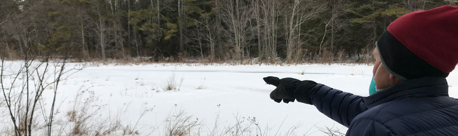
It’s a bitterly cold February day in Auburn. Robert Sanborn is walking his newly conserved property, as he does almost every day. A recent storm has blanketed the surroundings with snow; Murray Mill Brook is almost entirely obscured by the accumulation, though the water dutifully flows under the sheen of ice and powder, doing its duty to recharge a water supply that hundreds of thousands of people rely upon.
As he walks, he notes the ancient stone wall where Betty the Collie loved to nose through to find hiding woodchucks. Or the vast open field where he once landed a small airplane he was piloting. Or the old Boy Scouts camp on the shore of Murray Mill that is still used today.
And while the conservation value of this property cannot be overstated, for Robert Sanborn (who is very much understated) the easement protects much more. When he looks out at the sprawling fields and the network of trees he sees beyond watersheds and water cycles and into the past, where the stories of six generations flow through the land like a burbling brook, carried into the reservoir of shared memory, preserved forever.